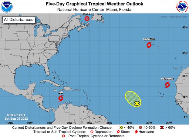
Tropical storm Ian, which could reach the Florida coast this week as a strong hurricane, advances this Saturday towards the central Caribbean with the forecast of strengthening, while Hermine continues its path north and will leave heavy rains in the Canary Islands (Spain) .
The 12:00 GMT bulletin from the US National Hurricane Center (NHC) reports that Ian’s maximum sustained winds reach 45 miles per hour (75 km/h), with stronger gusts, and that it is expected to become a hurricane this afternoon or Sunday night.
Ian is 300 miles (485 km) from the Jamaican capital, Kingston, and 570 miles (915 km) from the Cayman Islands and is moving west-southwest at 15 miles per hour (24 km/h) with maximum winds. sustained 45 miles (75 km/h).
The NHC forecast is for the center of Ian to move through the central Caribbean Sea today, pass southwest of Jamaica on Sunday, and near or over the Cayman Islands on Sunday night and early Monday.
Ian, according to the Miami-based agency’s forecast, will approach western Cuba on Monday.
Tropical storm force winds extend up to 45 miles (75 km) from the center of the system.
Hurricane conditions are possible in the Cayman Islands by early Monday, with tropical storm conditions possible by Sunday night.
Tropical storm conditions may be felt in Jamaica on Sunday.
Ian is expected to drop 2 to 4 inches of rain in southern Haiti and the southern Dominican Republic, with a local maximum of up to 6 inches, while 4 to 8 inches will be collected in Jamaica and the Cayman Islands, with a maximum local up to 12 inches.
From western to central Cuba 6 to 10 inches can be recorded, with a local maximum of up to 14 inches.
These rains can produce flash flooding and mudslides in highland areas, particularly over Jamaica and Cuba.
In the Florida Keys and the south of that US state, heavy rains could begin on Monday with the possibility of flooding.
TROPICAL STORM HERMINE
On the other side of the Atlantic, tropical storm Hermine will leave heavy rains in the Atlantic archipelago of the Canary Islands (Spain), in northwestern Africa.
The NHC forecast is that Hermine will cause heavy rains over the weekend in the Canary Islands, which may be accompanied by flash flooding in high areas.
Hermine was located at 8:00 GMT 360 miles (575 km) northeast of the Cape Verde Islands, moving north with maximum sustained winds of 40 miles per hour (65 km / h).
The tropical storm is moving near 10 miles per hour (17 km/h) and this motion is expected to continue through tonight before turning to the northeast late on Sunday.
The forecast is that it will begin to weaken tonight.
FIONA AND GASTON
Fiona, meanwhile, which has progressively lost strength, is located 200 miles (340 km) northeast of Halifa, the capital of the Canadian province of Nova Scotia, advancing with maximum sustained winds of 85 miles per hour (140 km/h). h).
The forecast is for the center of Fiona to move across the Gulf of St. Lawrence today and into the Labrador Sea on Sunday.
Although gradual weakening is forecast over a couple of days, Fiona is expected to maintain gale-force winds through this afternoon.
Finally, tropical storm Gastón is located 80 miles (130 km) west of the island of Faial, in the Atlantic archipelago of the Azores, and advances with maximum sustained winds of 50 miles per hour (85 km / h).
