
A reviewed magnitude 5.0 earthquake struck Central California at 10:49 p.m. Pacific time on Thursday, November 19, centered 10 kilometers northwest of Pinnacles near the San Benito and Monterey county line. The shallow tremor activated mobile early-warning alerts with no tsunami threat and no immediate reports of damage or injuries, according to the reviewed USGS event report.
The U.S. Geological Survey revised the mainshock down from an early-warning estimate of 5.4 and an automatic reading of 5.1, while faint shaking reached Los Angeles without coming from an LA earthquake. An earlier Reuters report placed the 6.7-kilometer-deep (4.16-mile) quake about 20 kilometers from Soledad and 40 kilometers from Salinas, before seismologists with the Northern California Seismic System finalized the magnitude at 5.0 using 78 seismic stations.
The USGS ShakeAlert system activated during the tremor and delivered alerts to phones across Central California. Two minutes later, at 10:51 p.m. Pacific time, the National Tsunami Warning Center in Palmer, Alaska issued an information statement ruling out any tsunami danger because the rupture occurred inland. The USGS assigned a green PAGER alert, its lowest impact tier indicating little or no expected casualties or economic losses, and rated landslide and liquefaction risk as green.
Foreshocks and aftershocks in the Pinnacles sequence
The mainshock sits inside an active seismic cluster that reached 68 recorded events on the USGS sequence page by Friday morning. Two magnitude-3 foreshocks preceded the main rupture by less than an hour, and the first measurable aftershock arrived three minutes after the mainshock.
| Time (PST, Nov. 19) | Event Type | Magnitude | Location or Detail |
|---|---|---|---|
| 9:53 p.m. | Foreshock | 3.1 | 56 minutes before mainshock |
| 10:12 p.m. | Foreshock | 3.3 | Second foreshock near Pinnacles |
| 10:49 p.m. | Mainshock | 5.0 | Depth of 6.7 km, 10 km NW of Pinnacles |
| 10:52 p.m. | Aftershock | 3.0 | First notable aftershock |
| 11:14 p.m. | Aftershock | 3.4 | 6 km NW of Pinnacles |
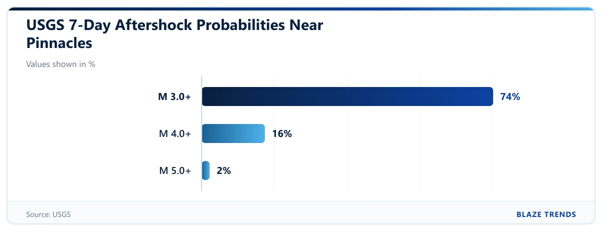
By 2:49 a.m. Pacific time on Friday, the USGS catalog logged 13 aftershocks of magnitude 2.5 or larger, led by the magnitude 3.4 tremor at 11:14 p.m., Nacionale reported. The USGS updates its aftershock forecast as new tremors occur, and its reviewed outlook gives a 74% chance of at least one magnitude 3.0 or stronger aftershock over the next seven days, alongside a 16% chance of a magnitude 4.0 or stronger quake. The agency puts the seven-day probability of another magnitude 5.0 or larger event at 2%, and less than 1% for magnitude 6.0 or higher.
Why the shaking was not an LA earthquake
Peak shaking near the epicenter reached an estimated Level VI on the Modified Mercalli Scale, a ground-intensity rating associated with strong shaking capable of waking residents and shifting light objects, according to Edhat and VOZ. Nearby Salinas, a Monterey County city of about 157,000 people, and surrounding towns in San Benito and Monterey counties felt the sharpest jolt, while CBS San Francisco reported shaking reaching north to Stockton. Exactly 2,873 people submitted Did You Feel It reports to the USGS, Edhat reported, including weak tremors logged 215 kilometers north in Sacramento, 393 kilometers south in Los Angeles, and 549 kilometers away near MCAS Miramar.
CBS San Francisco and SFGATE reported no injuries or structural damage as of Friday morning. The epicenter sits in the Gabilan Range near the San Andreas Fault zone, where the Pacific and North American tectonic plates slide past each other, though seismologists had not yet confirmed which specific fault strand ruptured, Beinsure reported. The area recorded smaller quakes earlier in 2026, including a magnitude 3.5 tremor 10 miles northwest of Pinnacles on July 9 and a magnitude 4.6 earthquake in Central California on April 2, neither of which caused reported damage.