
The Invisible Engine of the Atmosphere
Cyclonic circulations affect global weather patterns by acting as enormous atmospheric engines that scoop up heat and moisture from the tropical oceans and forcefully throw it toward the cooler middle latitudes. This rapid redistribution of energy regulates ocean currents, alters global precipitation, and keeps the Earth’s heat balance in check. Without these sprawling low-pressure systems, the equator would continuously boil, and the poles would freeze solid.
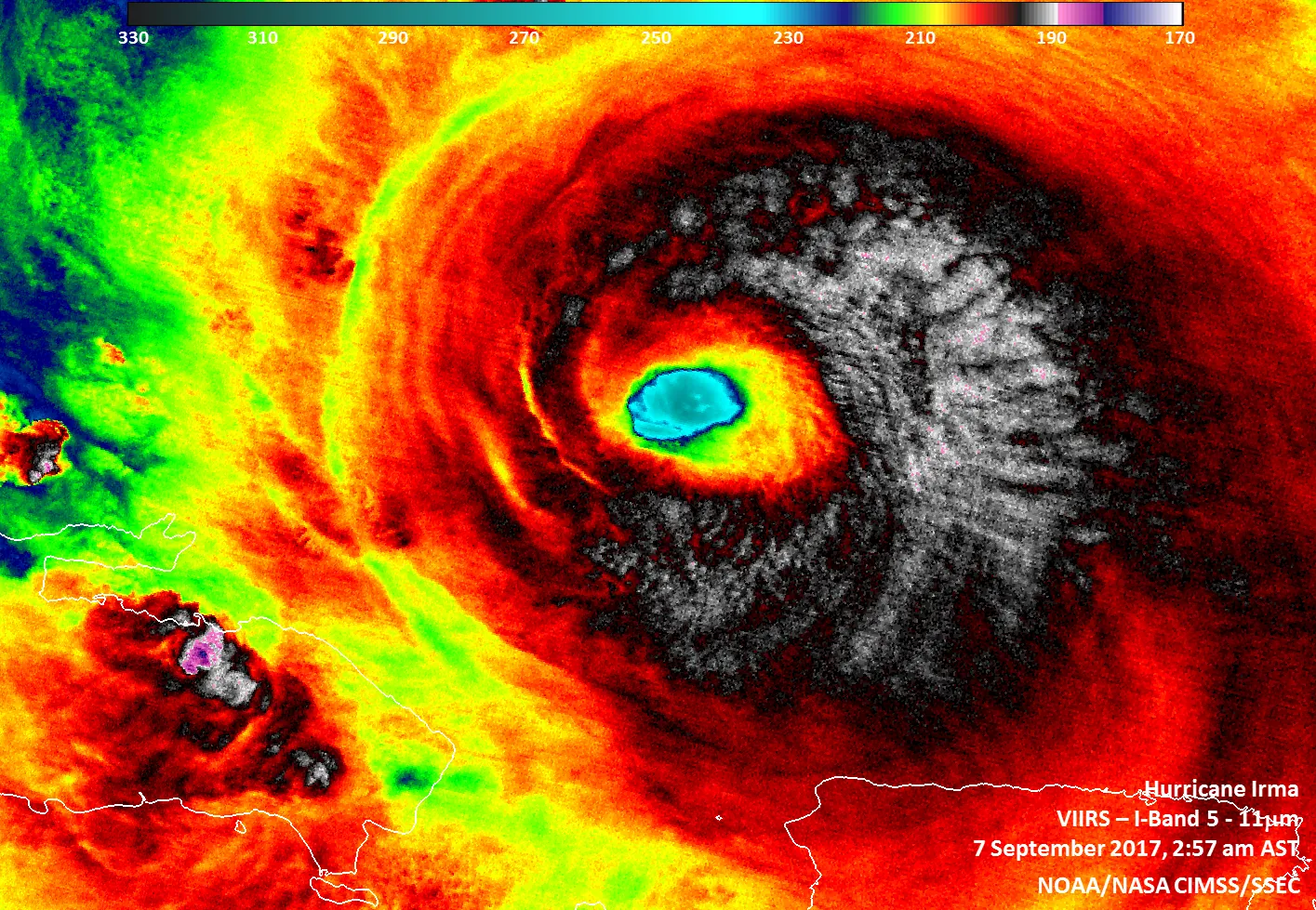
I spend hours looking at satellite imagery of these storms on my monitors. They look like beautiful, terrifying spinning tops made of cloud and rain. Most people view them strictly through the lens of local destruction. They watch the news, see the wind speeds, and worry about coastal damage.
But that localized view misses the true scientific scale of what is happening. These weather systems do a lot more than ruin a beach vacation. They actively move the atmosphere around the planet. The rain that falls on a farm in the Midwest or the drought that dries up a reservoir in Australia often traces its origins back to a cyclonic circulation spinning quietly over the ocean weeks prior.
The Science Behind Cyclonic Circulations
To understand how they change global weather, we first need to look at the mechanical parts of the storm. A cyclone is essentially a giant area of low atmospheric pressure. Because of the Coriolis effect, winds rotate counter-clockwise around the center in the Northern Hemisphere, according to the National Weather Service glossary. In the Southern Hemisphere, the exact opposite happens, and the winds spin clockwise.
You cannot just build a storm like this anywhere. You need a very specific set of ingredients. The atmosphere requires high humidity and strong, uniform winds high up in the air, usually up to 15 kilometers above the surface. You also need hot water to power the entire system.
The upper 60 meters of the ocean must reach at least 26 degrees Celsius to trigger formation, a threshold detailed by the Ocean & Climate Platform. That warm water acts like a gigantic chemical battery. It heats the air immediately above the ocean surface, causing massive amounts of water to evaporate.
As this warm, humid air rises, it begins to cool. The water vapor condenses back into liquid droplets to form clouds. This simple act of condensation releases incredible amounts of latent heat energy. That heat forces the clouds even higher into the atmosphere, dropping the surface pressure even further. The lower the pressure drops, the faster the surrounding air rushes in to fill the void.
This self-feeding loop creates the intense wind and heavy rain we see on weather radar. The storm will keep growing as long as it has access to that hot ocean water. Once the circulation moves over solid land or colder ocean waters, it loses its primary fuel source. Without the latent heat from evaporation, the engine simply sputters and dies.
Real-World Examples and Applications
When you zoom out, you start to see how these storms function as a global thermostat. They take excess heat from the tropics and push it away. This movement alters cloud cover and precipitation thousands of miles away from the actual path of the storm.
The intense evaporation over the tropics eventually has to fall as rain somewhere else. By vacuuming up moisture and transporting it across hemispheres, cyclonic circulations dictate the dry and wet seasons for entire continents. They also directly influence the water beneath them.
The strong, sustained winds of a cyclone drive oceanic upwelling. This physical churning pulls deeper, colder water to the surface. It helps regulate global thermohaline circulation, which is the large-scale movement of ocean waters around the planet. If you alter the ocean currents, you alter the air temperatures of coastal cities worldwide.
We saw a clear example of these interconnected systems during the 2026 El Niño pattern. Forecasts for the season showed how the Pacific Ocean temperature changes everything. The developing El Niño suppressed hurricane development in the Atlantic Ocean. But simultaneously, it churned up much more powerful tropical storms in the central and eastern Pacific.
This shifted extreme weather risks entirely. Regions like Mexico, Southern California, and Hawaii faced completely different precipitation patterns simply because the cyclonic engine moved westward. The moisture that normally would have drenched the Caribbean fell over the Pacific rim instead.
Another fascinating example is the Indian monsoon cycle. In late May 2026, central India experienced an intense heat cycle known locally as “Nautapa.” Temperatures hovered near 46 degrees Celsius.
This intense, localized heat created strong cyclonic circulations and low-pressure troughs right over the plains. The rising hot air acted like a continental vacuum. It forcefully drew moisture-laden winds in from the Arabian Sea and the Bay of Bengal. This atmospheric pull eventually aided the arrival of the life-sustaining monsoon rains across the subcontinent.
What Scientists Still Don’t Know
The relationship between a warming planet and cyclonic activity is complicated. People often assume that warmer global temperatures automatically mean more storms every single year. The hard data paints a different picture, and meteorologists spend a lot of time tracking these exact metrics.
Researchers look closely at historical records to find trends. A review of historical Atlantic hurricane data does not yet provide compelling evidence for a century-scale increase in storm frequency due to greenhouse warming, as analyzed by NOAA. We are not necessarily seeing more individual storms forming on the radar.
But the storms that do form behave differently. Warmer sea surface temperatures generate longer and more intense circulations. Because the water is hotter, the storm has access to more latent heat energy. It is like putting high-octane fuel into a car engine.
Long-term studies note that this future warming leads to a distinct upward trend in tropical cyclone destructive potential. The storms hold more water and spin with higher wind speeds. They last longer before breaking apart.
Scientists are still trying to build better computer models to track exactly how these intense, isolated events will alter long-term global precipitation maps. We know they move heat, but the exact geographical destinations of that heat are shifting as the oceans warm.
Common Myths Debunked
The most common misconception is that cyclones are purely destructive errors in the weather system. People think the Earth would be better off without them. They are actually entirely necessary.
Without them, the tropics would continue to heat up to unlivable temperatures, and the poles would grow increasingly colder. They are the Earth’s primary mechanism for venting tropical heat. We rely on them to keep the planet habitable.
Another myth involves the depth of the ocean. Many people think a large cyclone churns up the entire ocean floor and pulls freezing water up from the darkest depths. In reality, the storm only interacts with the top 60 meters of water.
If that specific top layer is warm, the storm grows. It does not matter how deep or cold the water is a mile down. The atmospheric engine only drinks from the very surface.
People also tend to confuse cyclonic circulations with tornadoes. While both involve spinning air and low pressure, they operate on completely different physical scales. Tornadoes form over land from localized thunderstorms and typically last for a few minutes. Cyclonic circulations form strictly over the ocean, span hundreds of miles across, and can last for weeks.
There is also the classic myth about the Coriolis effect making toilets flush in opposite directions in different hemispheres. The Coriolis effect is real and it dictates the rotation of cyclones. But it only works on an enormous scale. The water in your bathroom drain is influenced entirely by the shape of the bowl and the angle of the water jets, not the rotation of the Earth.
Frequently Asked Questions
How do cyclones affect the global climate?
Cyclones influence global climate by moving large amounts of water and air over extremely long distances. This process redistributes heat from the tropics to the middle latitudes. The movement alters global cloud cover and regulates oceanic thermohaline circulation through upwelling.
What factors are needed for a cyclone to form?
Cyclones require a specific set of atmospheric conditions. They need high humidity, strong and homogeneous high-altitude winds, and sea surface temperatures higher than 26 degrees Celsius. These warm oceanic waters heat the air and provoke massive water evaporation to fuel the storm.
Is climate change causing more frequent cyclones?
Historical data does not yet show compelling evidence of a substantial greenhouse warming-induced increase in the overall frequency of hurricanes. However, warmer ocean temperatures are expected to make the storms that do form significantly more intense and last longer.